Found this in the middle of the woods. About knee height, made of cement. It was along a old roadbed. What is this thing?
Not every piece of history comes in the form of a famous landmark or a towering monument. Sometimes, the most revealing clues are the smallest ones—easy to miss, quietly weathering away at the edge of a trail.
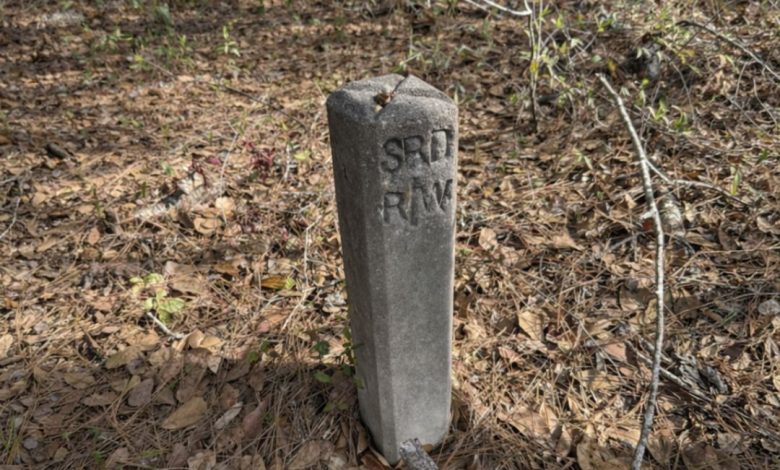
Imagine walking through the woods on an old path lined with trees, leaves, and patches of brush. Everything looks natural and untouched until you notice a short concrete post standing off to the side. It may seem unimportant at first, but objects like this often tell a much bigger story.
In many cases, that post is an old State Road Department right-of-way marker, a relic from the days when the area was part of an official transportation route. What looks like a forgotten block of concrete may actually mark the boundary of a road that once connected communities, carried travelers, and shaped the land around it.
These markers were used to define the legal limits of a roadway. The letters often found on them—such as “R/W,” meaning “Right of Way”—identified land reserved for road construction, maintenance, and public access. Surveyors and engineers placed them to make sure roads stayed within their designated boundaries.
That detail matters because it changes how we see the landscape. A narrow trail in the woods may not be just a trail. It may be the remains of a formally planned road, once measured, graded, and built as part of a larger infrastructure system. The concrete post is proof that the route was official, not simply a casual path worn down over time.
One reason these markers continue to fascinate explorers and local history enthusiasts is their durability. Roads can disappear, but concrete markers often stay behind for decades. Pavement cracks, gravel sinks into the soil, and vegetation slowly takes over. Trees grow. Brush thickens. What was once a traveled roadway can fade into what looks like ordinary forest.
The marker, however, remains.
Because of that, it often becomes the last visible evidence that a road ever existed there at all.
Once people learn to recognize these markers, they begin to spot other signs nearby. A strip of unnaturally level ground, a shallow drainage ditch, or a patch of buried gravel can all point to an old roadbed. Suddenly, the woods stop looking random. The land begins to read like a map of the past.
These markers were especially useful near curves, bridges, intersections, narrow roadway sections, and property lines. In those places, clearly defined boundaries were important for road crews, surveyors, and maintenance teams. Even though most drivers probably passed them without a second thought, they played an important role in how roads were built and preserved.
What makes discoveries like this so compelling is that they represent ordinary history. They are not tied to celebrity, war, or grand architecture. Instead, they reflect the everyday systems people depended on—roads that carried workers, families, farmers, and travelers from one place to another.
That is what gives a small concrete post its quiet power.
It stands as a reminder that today’s peaceful trail may once have been a busy corridor of movement and connection. Long after the traffic is gone and the road itself has faded, the marker continues to hold its place, silently preserving a piece of the story.
For hikers, photographers, and curious explorers, moments like this can completely change the experience of being outdoors. What first feels like a simple walk through nature becomes something deeper: an encounter with hidden infrastructure, forgotten routes, and the layers of history still embedded in the land.
In the end, that weathered concrete post is more than just leftover construction material. It is a boundary marker, a historical clue, and a surviving link between the present landscape and the people who once moved through it. Small, unassuming, and easy to overlook, it proves that sometimes the past does not vanish at all.
It simply waits to be noticed.
